Annual Meeting 2025
Field Trips

Columbia Gorge, Photo by Kristin Currin
Click on the field trip name for additional information.
Please check your confirmation email for the link to select your field trips. This page contains descriptions only.
Map links at the end of this list provide general locations for most trips.
Hike mileage is total out and back.
Botanical names may not be current on plant lists. Please print your own copy if desired. Paul Schlicter’s site science.halleyhosting.com is safe to access/print despite security warnings.
Box lunch is not provided this year. Be prepared to bring or buy your own.
Please reimburse your carpool driver $5-10 for fuel and maintenance.
Carry lunch and water, a charged phone, and be prepared for any weather including rain or significant wind in exposed areas. Sun protection is advised. Binoculars, trek poles, tick repellent, gaiters, and field guides are options. Driving may involve unpaved roads. Some trips need parking permits; check your trip description and the resource links at the bottom of this page.
Learn more about your Hike Leaders.
Friday Field Trips
12pm-4pm

Dancing Rock Preserve, East Gorge WA, Photo by Jason Clinch.
Important Information for Friday Hikes
THE MEETING PLACE FOR FRIDAY HAS CHANGED
Friday trips depart at Noon, meet your group at the beach at the east end of Hood River Inn 1130am
Please park in the lower south-east parking lot of the Hood River Inn. Maps to be sent in email.
Please reimburse your carpool driver $5 for gas and maintenance.
Meet us “ where the sidewalk ends” under the Douglas Fir tree.


Friday trips will highlight the use of iNaturalist as an ID and data collection tool. Please download the phone app and know your login information. Be sure to join our NPSOPDX25 Annual Meeting Gorge BioBlitz project on or after May 15.
If you’ve never tried iNaturalist, now’s your chance to see how easy it is to quickly (and usually accurately!) identify plants. It's fun! And the app will keep a simple record of your observations. Your photo ID’s, when corroborated by other online observers, help scientists learn what’s blooming where in real time. Information on using iNaturalist is here. Explore the new AI version here.
Please take a minute to view these slides: Mike McKeag: A Beginner’s Adventure with iNaturalist. Use arrow keys to advance slides.
Friday Trips Depart at Noon:
F1 Dancing Rock Preserve East Gorge, WA
Easy 1.5 Miles 100’ Elevation Gain
Leader: Jason Clinch and Kaitlin Andersen
This 64-acre preserve, owned by the Friends of the Columbia Gorge Land Trust, is near Columbia Hills State Historic Park. Closed to the public, it’s an exclusive opportunity to explore a unique Missoula Flood-scoured landscape, take in panoramic views of the Gorge, and enjoy the wildflowers of its biscuit scablands, vernal pools, swales, and a kolk pond!
F2 Hood River Mountain Hood River, OR
Easy/Moderate 2.5 miles 570’ Elevation Gain
Plant List 1 Plant List 2 Plant List 3
Leaders: David Anderson and Andrew Stern
Hood River Mountain as described by Russ Jolley (Wildflowers of the Columbia Gorge, P. 278) is where green west-gorge transitions to dry east-gorge. Wander a meadow of floral delights, then make a gentle climb on an adjacent dirt road to find balsamroot, lupine, penstemon, paintbrush, and majestic views of Mt. Hood and the Gorge.
F3 McCord Creek Upper Falls CRG, OR
Easy/Moderate 3.5 Miles 670’ Elevation Gain
Leaders: Kieran Hanrahan and Kim Brown
Climb a moderate hillside through conifers and lush undergrowth to vertical cliffs supporting unusual flora sustained by rocky seeps. Sunny swaths of Corydalis and more border nearby McCord Creek and majestic Upper McCord Falls.
Easy/Moderate 3.5 Miles 600’ Elevation Gain
Leader: Nicole Wiseman and James Mickley
Mosier Plateau, a mostly flat clifftop paradise with a commanding view of the Gorge, ripples with the colors of over 50 flowering species from March to May. Reached by ascending Mosier Creek, the access trail and canyon walls support cliffside species, wildlife, and birds.
F5 Mosier Twin Tunnels Hood River, OR
Easy 9 Miles Elevation Gain 430
Leaders: Lecia Schall and Beth Markhart
As part of our Fire Succession Series, explore with us the Mosier Twin Tunnels section of the Historic Columbia River Highway (HCRH) State Trail from Hood River to Mosier. This section was closed in July 2024 due to the Microwave Tower Fire but reopened in October.
F6 Native Plant Restoration Walk The Dalles,OR
Easy .5 Miles Flat
Leaders: Barbara Robinson and Judi Sanders
Under Barbara’s watchful eye, this native plant restoration project on the grounds of the Columbia Gorge Discovery Center has involved countless volunteer hours since its beginning in 1997. We invite you to take an easy stroll along the trail, learn about the project from its creator, and enjoy its natural beauty. Be sure to check out this video: FOCG: Barbara Robinson: the Wildflower Woman
Please meet Judi to organize your carpool at Waterfront Park. Barbara will meet the group at 12:30 at the Discovery Center entrance in The Dalles.
F7 Phone Photography Workshop at Rimrock Mosier, OR
Easy .5 miles Mostly Flat
Leader: Mike McKeag and Frank Howarth
Mike will lead this photographic exploration of Rimrock, his Mosier property, which preserves a lovely variety of blooming natives in an Oregon white oak woodland. He has useful tips and tricks to help make your phone photos eye-catching, professional looking, and ready for use on iNaturalist.
F8 Russ Jolley Wayside Mosier, OR
Easy .5 Miles Flat
Leaders: Drew Merritt, Ann Maslen, Linda Hardie
Explore this magical pocket of dirt between the Columbia River and I-84 near Mosier. Russ Jolley, NPSO Fellow and Gorge conservation hero, established it as a haven for native plants threatened during freeway construction. NPSO members have lovingly tended it for decades. It was recently given official Wayside status by ODOT. There is no ramp to this Wayside. Slow down on the shoulder, and use caution entering and exiting. (Milepost 68, I-84 Westbound)
F9 Tom McCall Point Mosier, OR
Moderate 3 Miles 1030’ Elevation Gain
Leader: Roger Brewer and Ash Gill
Follow this scenic trail to the top for spectacular Gorge and mountain views, open hillsides, and enchanting wildflowers.Use your iNaturalist App to make observations in support of Oregon Flora’s ongoing species verification project.
F10 Wahclella Falls Cascade Locks, OR
Easy/Moderate 3 miles 275’ Elevation Gain
Leader: Mary Hayden and Courtney Knudsen
Follow Tanner Creek up a gently sloping canyon to the falls, a two-tiered 80’ cascade into a deep green splash bowl. A 1973 landslide dislodged house-sized chunks of the canyon wall into the creek, now green with mosses, saxifrages, and other damp cliffside species. We’ll try identifying them with iNaturalist.
Saturday Field Trips
9am-4pm

Columbia Desert Parsley, Photo by Mary Hayden
Hike groups gather at breakfast ( 7:00-8:30) in the Conference Room, and at 8:30am in the hotel’s far east parking strip along the fence to join carpools. Look for field trip signs. Click here for a map of the Hood River Inn parking lots. If you’re a reliable driver with a clean, reliable car and a full tank or charge, tell your leader how many you can transport. Park near your group. Field Trips depart at 9am.
Saturday Hikes Depart at 9am
SA1 Bald Butte East Mt. Hood, OR
Moderate 3.5 Miles 1000 ’Elevation Gain
Leaders: Drew Merritt and Kristin Currin
Enjoy a unique ridgetop ramble along the divide between dry east Cascade and wet west Cascade ecoregions. Enjoy a diverse array of flora from each region as they meet and mingle, plus enchanting views of Mt. Hood and surrounds.
Moderate 5.5 miles 1250‘ Elevation Gain
Leader: Roger Brewer and Chealsey Rosebrook
Ascend through shady forest and lush undergrowth to emerge at the cliff's edge. The trail culminates at Nancy Russell Overlook with some of the finest views in the gorge. May is the perfect time for bloom with everything from deep woods and sunny meadow habitats to damp riparian pockets and rocky cliffs.
SA3 Chenoweth Bench The Dalles, OR
Easy 3.5 Miles 620’ Elevation Gain
Leaders: Brance Morefield, Christina Mead and Denise Hanggi
Enjoy a scenic ramble across this gently rolling table land above The Dalles dotted with vernal pools and special and rare flowers including Downingia, Marsilea, Beckman grass, and Quillwort. Dozens of native species are scattered within a small area of shortgrass prairie.
SA4 Four Sisters Preserve The Dalles, OR
Easy/Moderate 4-5 Miles 850’ Elevation Gain
Leader: Virginia Bowers and Nora Dunkirk
Explore sloped fields of wildflowers, scattered patches of Oregon white oak, and seasonal vernal ponds with unusual and rare species. Virginia is especially fond of this unique property she helped acquire for Columbia Land Trust. The Four Sisters, a row of basalt monoliths deposited by the Ice Age Floods, keep silent watch over this special preserve.
SA5 Klickitat Wildlife Area: Soda Springs Unit Lyle, WA
Easy/Moderate 4 miles Elevation Gain: 200’
Leaders: Paul Slichter and Susan Saul
The Soda Springs Unit consists of grassland, scrubland, oak forest, and Pine/Douglas fir forest with biscuit-swale topography and abundant and unusual wildflowers. Access is on old farm roads with some cross country walking. Discover Pass needed by drivers.
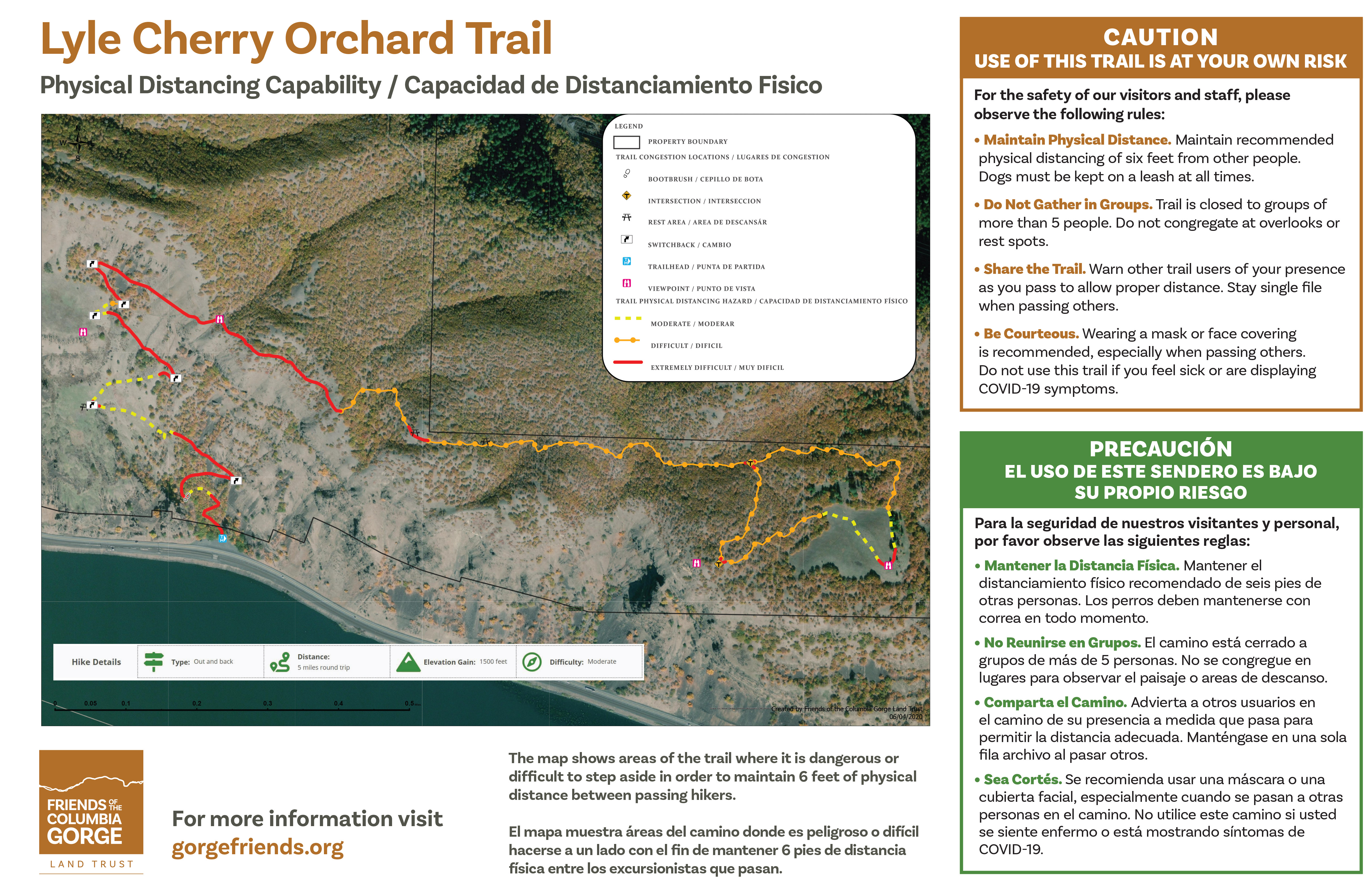
SA6 Lyle Cherry Orchard Lyle, WA
Moderate/Strenuous 6.5 Miles 1100’ Elevation Gain
Leader: Sara Woods and Frances Fischer
Follow this recently refurbished trail up a wooded slope to scenic openings, rocky outcrops, meadows, open oak woods, spectacular wildflowers, and outstanding views of the Gorge. A deserted farmstead with old cherry trees marks the turnaround point.
SA7 McCord Creek Upper Falls Warrendale, OR
Easy/Moderate 3.5 Miles 670’ Elevation Gain
Leaders: David Andersen and Andrew Stern
Climb a moderate hillside through conifers and lush undergrowth to vertical cliffs supporting unusual flora sustained by rocky seeps. Sunny swaths of riparian growth bloom along nearby McCord Creek with views of majestic Upper McCord Falls.
SA8 Mill Creek Ridge The Dalles, OR
Easy/Moderate 5.4 Miles 950’ Elevation Gain
Leaders: Kate Conley and Kaitlin Andersen
Ascend an old road through Oregon white oak and Ponderosa woodlands and emerge onto a spectacular rolling ridge of wildflowers, rock gardens, and expansive views of two river valleys, the Gorge, and Mt. Hood.
SA9 Monte Cristo Troutlake, WA
Moderate 4.1 Miles 1000’ Elevation Gain
Leaders: Kieran Hanrahan and Kim Brown
Ascend and descend alternately through shady forest, open flats, and rocky ridges for a myriad of unusual floral offerings and valley views.The ridgetop provides both dry grass meadows and rock gardens with wildflowers usually found further east. Parts of the area were burned in the early 1900s, but some older conifers are approaching old growth status.
SA10 North Section Line Trail #451 Parkdale, OR
Moderate 4.5 miles 800’ Elevation gain
Leader: Jason Clinch and Courtney Knudsen
Mill Creek Research Natural Area (RNA) was established to represent a variety of mixed stands including mature Douglas-fir, ponderosa pine, and California white fir. We’ll mostly stick to the ridgetop where topography is level to moderately-sloped with prairie openings, a spring, several intermittent creeks, an unusual variety of flowers, and lovely mountain views.
SA11 Old Salmon River Trail Welches, OR
Easy/Moderate 4 miles 200’ Elevation Gain
Leaders: Mary Hayden and Cheryl Brock
This shady meander through massive cedars, big leaf maple, old growth fir, and western hemlock follows the rushing course of the Salmon River. Look for moist forest beauties, cliffside and riparian species, swaths of Corydalis, and the bubbling song of the American Dipper
SA12 Rowena Plateau Shasha Loop Mosier, OR
Easy 2.5 Miles 250’ Elevation Gain
Leaders: Barbara Robinson and Cloudy Sears
Wander a clifftop plateau with outstanding gorge views, fields of wildflowers, and remnant kolk ponds scoured out during the Ice Age Floods. Learn about Barbara’s decades of dedication to acquiring and restoring this unique area. Over 500 species make this an area of botanical significance.
Meet Cloudy to organize the carpool. Barbara will meet the group at Rowena Plateau at 9:30am.
SA13 Snipes Mountain:Gotchen Creek Mt.Adams, WA
Moderate 5 Miles 500’ Elevation Gain
Leaders: Beth Markhart and Ash Gill
Explore the beautiful slopes of Mt. Adams and notice the luxuriant succession of growth since the Cougar Creek Fire of 2015. Northwest Forest Pass needed.
SA14 Stacker Butte Columbia Hills Preserve, WA
Moderate 5.1 Miles 1145’ Elevation Gain
Leaders: Ethan Coggins and Carolyn Wright
Ascend a maintenance road to the Columbia Hills Preserve’s highest point and explore its sloped meadows of exquisite wildflowers, stands of Oregon White Oak, and commanding views of the gorge and Cascade volcanoes. Enjoy forays for Cusickiella, Boechera, and other special plants off the beaten path. Discover Pass required for each driver
SA15 Weldon Wagon Road Husum, WA
Moderate 5.5 Miles 1290’ Elevation Gain
Leaders: Ron Klump and Nicole Wiseman
Explore this early 1900’s commerce route where local produce was transported to market, now a scenic trail through conifer forest, white oak woodlands, sloped fields of riotous color and variety, and stunning views of the White Salmon River valley. Named for roadbuilder Elwin Weldon.
SA16 Wind River Historic District Whistlepunk Trail Carson, WA
Easy 4.5 Miles Level
Leader: Lecia Schall and Jeff DeBell
Established as an administrative site for the US Forest Service after the Yacolt Fires of 1906, this historic landscape covers 65 acres. Enjoy a logging history lesson and shady forest walk with understory and wetland species in abundance. If time allows, we’ll visit the Wind River Nursery, Experimental Station, and Arboretum. Northwest Forest Pass required for each driver.
Sunday Field Trips

Russ Jolley Camas Patch, Photo by Lecia Schall.
8:30am: Join carpools in the hotel's far east parking strip along the fence. Be sure you’ve completed check-out.
9:00am: Field Trips Depart.
Self-Guided Trips may depart at any time.
Sunday Guided Hikes Depart at 9am:
SU1 Eagle Creek Trail, Punchbowl Falls, Cascade Locks, OR
Easy/Moderate 4 Miles Elevation Gain: 750’
Leaders: Beth Markhart and Roger Brewer
This much-loved trail suffered a fire in 2017, but the regrowth has been remarkable, and many opportunities for floral discoveries remain. Deep canyons, vertical cliffs, numerous bridges, side creeks and waterfalls make this walk a delight. Take care on narrow trails and wet rocky areas, and don’t forget to seek out cliffside beauties in cracks and seeps.
SU2 Panakanic Meadows Husum, WA
Easy 1-2 Miles Mostly Flat
Leaders: Joy Markgraf, Paul Slichter and Susan Saul
Joy opens her unique property for a special exploration of a rarely visited site managed as a refuge for special plants and wildlife, including Sandhill cranes. Through careful haying, grazing, and restoration projects, an unusual vernal wetland habitat is well on its way to recovery. Expect gravel roads and possible watery walking conditions.
SU3 Chenoweth Bench The Dalles, OR
Easy 3.5 Miles 620’ Elevation Gain
Leaders: Brance Morefield and Christina Mead
Enjoy a scenic ramble across this rolling table land above The Dalles dotted with vernal pools and special and rare flowers, including Downingia. Dozens of native species are scattered within a small area of shortgrass prairie and wetland.
Self-Guided Hikes May Depart at Any Time:
Easy/Moderate 1.8 Miles 800’ Elevation Gain Distance from Hotel: 28 Miles
Beacon Rock was a cinder cone volcano before Ice Age floods scoured away its flanks and left the massive basalt core seen today. Nick on the Rocks explains the history. A safe trail to the top affords expansive gorge views. Discover Pass is required for the adjacent state park.
Easy/Moderate 2 Miles 220’ Elevation Gain Distance from Hotel:9 Miles
This favorite spring gathering place for wildflower enthusiasts never fails to delight, especially in the earlier months and after good spring rains. A variety of trails and terrains both open, creekside, rocky, wooded, sloped, and flat, make for multiple habitats. Don’t forget to check out the paved universal access trails across the road.
SG3 Deschutes River State Rec. Area– Ferry Springs OR
Easy/Moderate 4.8 Miles 450’ Elevation Gain Distance from Hotel: 36 Miles
The valley of the Deschutes as it enters the Columbia has an amazing variety of habitats and plant species. The trail to Ferry Springs affords expansive views of the Deschutes valley. Wetland species abound near the spring, and open sloped meadows are colorful in May. On the return trail along the Deschutes, white alder is common. Look for mulberry, black walnut, almond, and other trees planted by early homesteaders. Navigate to the campground on the east bank of the Deschutes River and park at the far south lot.
SG4 Dry Creek Falls Cascade Locks, OR
Moderate Miles: 4.4 Elevation gain: 700’ Distance from hotel: 21 miles
Dry Creek Falls plunges 74 feet over a basalt wall in a secluded forest amphitheater near Cascade Locks. It is easily reached via the Pacific Crest Trail and is a popular destination for those interested in a short, woodsy hike with plenty of Gorge ambience. Trail begins near the Bridge of the Gods ramp or via Moody Ave in Cascade Locks.
SG5 Government Cove Peninsula Cascade Locks, OR
Easy/Moderate 2 Miles Elevation gain: 250 Distance from Hotel: 18 Miles
Enjoy a leisurely walk around an old quarry to view wildflowers on cliff fronts, basalt bluffs, meadows, and sandy flats, along with inspiring gorge views. Westbound on I-84, take exit 47. Turn right at the bottom of the exit ramp, go a quarter mile and park near the gate.
SG6 Great Camas Patch Carson, WA
Easy .25 Miles Slight slope Distance from Hotel : 18 miles
Explore a hidden gem dear to the heart of gorge activist and NPSO fellow Russ Jolley. Annual work parties have eradicated a massive Scotch Broom infestation and restored camas meadows with breathtaking views upriver. Jolley’s iconic guide, Wildflowers of the Columbia Gorge, features this view on its cover. Take Carson Depot Rd. At the dead end, look left.
SG7 Humble Roots Nursery Mosier, OR
Easy .25 Miles or less Flat Distance from Hotel: 9.2 Miles
Explore an amazing array of Columbia Gorge native plants sustainably and ethically sourced and nurtured by the expert owners who are happy to answer questions and provide plants to try in your own garden. Drew and Kristin also make available The Native Plant Primer, their latest book and essential guide for Oregon native plant gardeners.
Check out this awesome video featuring Kristin: Beauty in Biodiversity
SG8 Klickitat Rail Trail Lyle, WA
Easy Flat, Slight Incline Distance from Hotel: 12 miles
The gentle grade of this repurposed railbed affords easy walking and lovely river views as it follows the nationally designated Wild and Scenic Klickitat River. Thirteen miles through oak and pine woodlands and wildflower waysides ends at the old mill town of Klickitat. At the Wahkiacus trailhead, turn up Swale Creek to discover remote and beautiful Swale Canyon.
SG9 Memaloose Hills Mosier, OR
Easy 2.8 Miles 650’ Elevation Gain Distance from hotel: 16 miles
Find a popular destination for wildflower meadows, open oak woodlands, and expansive gorge views. Best access is from Memaloose rest area on I-84 Eastbound past The Dalles. Take the trail at the west end and continue up a wooded slope. At the top, enjoy the overlook, then cross Hwy 30 to find the trail. Or take Hwy 30 from Mosier and park near the overlook. Parking is limited.
SG10 Native Plant Restoration Tour The Dalles,OR
Easy .5 Miles Flat Distance from Hotel: 17 miles
Under Barbara Robinson’s watchful eye, this native plant restoration on the grounds of the Columbia Gorge Discovery Center has involved countless volunteer hours since its inception in 1997. We invite you to take an easy stroll along the trail, learn about the project, and enjoy the natural beauty. Barbara will lead Friday’s trip in person. Check out this video: FOCG: Barbara Robinson: the Wildflower Woman
(see Friday)
SG12 Strawberry Island Loop North Bonneville, WA
Easy 4 miles Mostly flat
Hike on botanically rich Columbia River islands created when Bonneville Dam was built. Other lowland hikes are also available on the North Bonneville Discovery Trail.
SG13 Viento State Park to Lindsey Creek OR
Easy 5.6 miles Mostly flat
This scenic section of the Columbia River Gorge Historic Highway Trail includes numerous waterfalls between Viento Park and Starvation Creek wayside.
SG14 Wahclella Falls Cascade Locks OR
Easy/Moderate 3 miles 225’ Elevation Gain Distance from Hotel: 24 Miles
Follow Tanner Creek up a gently sloping canyon to the falls, a two-tiered 80’ drop into a deep green splash bowl. A 1973 landslide dislodged house-sized chunks of the canyon wall into the creek, now green with mosses, saxifrages, and other damp cliffside species.
Helpful Links
Passes for Drivers
Parking
Friday field trips: Waterfront Pay Lots or free parking on the nearby fishing spit.
All Other Field Trips: Use the hotel's east lot, rear strip nearest the freeway.
Maps
Pacific Northwest Wildflowers: Region: Columbia River Gorge (West)
Pacific Northwest Wildflowers: Region: Columbia River Gorge (East)
Plant Lists
Videos
Navigation:
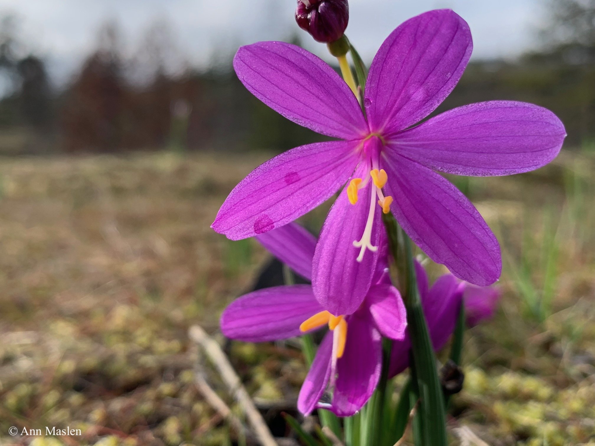
Annual Meeting Header Photo: Grass Widow (Olsynium douglasii), by Ann Maslen